2018·IREMI waypoint on airway UL302, Pacific Ocean off the southern coast of Peru
Peru.Pacific off Peru · the 'cities' under the clouds seen by LXP2371
On a flight reported on 4 December 2018, the crew of Lan Perú flight LXP2371, on the oceanic airway UL302 between the ASEPU and IREMI waypoints, radioed Chile's oceanic control that 'the sea is lit up': a patch of white lights some 80 miles long, 'as if there were cities under the clouds', which they thought was too large for a fleet of boats.
Read the rest of the summary
The controller did not believe there was a fishing fleet that large either. SEFAA studied the audio, the photos the captain sent over WhatsApp and information from the Chilean Navy, and concluded in 2019 that it was a high-seas fishing operation, probably giant-squid boats that use powerful lamps.
Tier A · AcceptableWhat do they mean? →
Institutional evidence: several identified independent witnesses, or contemporary official documentation, without an instrumental record to corroborate them.
What it was
91%natural or human cause
Most likely explanation: human light or activity
See the split across the six explanations
Natural or human cause
No known cause
Primary documents
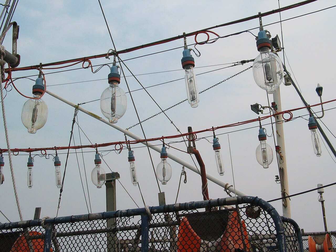
Context · the lamps of a squid-fishing boat
Rows of powerful discharge lamps in the rigging of a squid-jigging boat, photographed in port at Lakes Entrance (Australia) in 2007. It is not an image of the event or of the fleet LXP2371 saw: it shows the kind of lighting these boats use to draw squid at night, the cause SEFAA gave for the patch of light.
Squid jigger electric lamps.JPG (Bluedawe) · Wikimedia Commons · CC BY-SA 3.0 · open original
SEFAA (Chilean DGAC) report, case no. 899, IREMI (UL302), reported 4 December 2018
Three-page report by the official anomalous aerial phenomena section. It reproduces the captain's two photographs, transcribes the radio exchange between LXP2371 and oceanic control, lists the queries to the maritime authority, the Navy and the police, and concludes that it was a high-seas fishing operation, 'probably giant-squid fishing boats'. A DGAC work with no open licence, so it is linked rather than hosted.
SEFAA, Dirección General de Aeronáutica Civil de Chile · view source
The night in question
The report by SEFAA, the section of Chile's Directorate General of Civil Aviation (DGAC) that studies anomalous aerial phenomena, dates the report to 4 December 2018 and places the event at the IREMI waypoint on airway UL302, in the region the DGAC calls 'Oceanic': the high-seas stretch flown by aircraft between Lima and Santiago, far from the coast. It does not give the time. An air traffic controller passed on information about what the report calls a 'flight contingency', reported by radio by the pilot of Lan Perú flight LXP2371. According to the report, the crew saw an illuminated area 'the size of medium-sized cities', with white lights they thought too large to be the lighting of a fleet of boats; the largest cluster lay 130 nautical miles north of the ASEPU waypoint and stretched east to west for about 80 miles, and there was another patch of light, on its own, south of the ELASA waypoint.
The recording of the 124.9 MHz frequency of the Oceanic Area Control Centre, which SEFAA transcribed, preserves the exchange. The pilot asks, 'maybe a bit of a silly question', whether there is maritime activity between ASEPU and IREMI, 'because we are over the sea. Below we see some clouds and the sea is lit up'. The controller suggests fishing boats, though he adds that in that area, days earlier, 'quite a lot of UFO-type lights have been seen'. The pilot says he heard an audio and saw news about that, but that it is 'quite a big patch', some 80 miles, that 'lights up a lot'. The controller replies that he does not think 'there is a fishing fleet as big as 80 miles' in that sector and has no idea what it might be. The pilot: 'It looks as if there were cities under the clouds. It looks strange.' After being given radar contact at flight level 370, the pilot adds that some 40 miles ahead there is 'another patch on the sea. With a big light. It looks like a lighthouse.' The controller thinks of a TACA Perú Airbus 319 flying 56 miles ahead at level 350; the pilot rules it out: it is 'below, on the sea. It is far too strong. It could not be a ship or a plane.' And he offers to send the photo over WhatsApp.
Between December 2018 and May 2019, SEFAA asked the controller for an interview. It later received from him the images the captain had sent him over WhatsApp, which stripped their metadata: the office could not confirm the exact date or place of the shots. The two photos it publishes are almost black, with a band of yellowish lights near the bottom. On 8 March 2019 it wrote to the Antofagasta Maritime Governorate asking it to identify the vessels sailing within about 150 miles of ASEPU (21° 10′ S, 74° 31′ W) and ELASA (24° 00′ S, 73° 37′ W); on 30 July it asked for the cooperation of the Navy's representative on the committee, from the Naval Aviation Command, and of the Investigations Police representative. The analysis of the radio communications on that frequency, between various aircraft and oceanic control, was, the report says, consistent with the images and with the hypothesis of fishing operations using lights. The conclusion, dated 31 July 2019, classifies the case as 'Resolved': on the strength of the radio account, the pilot's photographs and the information provided by the Chilean Navy, what was reported was a high-seas fishing operation, 'probably giant-squid fishing boats that use powerful lamps at will to attract the said species'.
Why it matters
The case shows how hard it can be to recognise from 37,000 feet something as ordinary as a fishing fleet. The two professionals talking on the radio, the pilot and the controller, ruled out live the explanation SEFAA eventually gave: the pilot said the patch was too big and too bright for boats, and the controller that he did not believe there was an 80-mile fleet there. The scale is easily misjudged. The pilot only said 'Below we see some clouds and the sea is lit up'; one possible reading, made for this record and not by the report, is that many scattered lights, seen through that cloud layer, blurred into a continuous glow, 'as if there were cities underneath'. That the controller brought up the 'UFO-type lights' of the previous days at once, and the pilot the news he had seen, also shows the atmosphere in which the report was made.
The report has limits worth stating. It gives neither the time nor the exact date of the flight, only that of the report. The photos arrived without metadata, so on their own they do not prove when or where they were taken. It does not transcribe what the Antofagasta Maritime Governorate or the Investigations Police answered, and of the Navy it says only that it provided information, without detailing it; in the conclusion, the identification of the type of fishing carries a 'probably'. Nor does it explain separately the third light, the one the pilot saw some 40 miles ahead, to the north, compared to a lighthouse and said could not be a ship, distinct from the largest cluster and from the patch south of ELASA, beyond folding it into the same operation. And the coordinates it gives for ELASA do not state the hemisphere of the latitude, though from the context it is south.
Even so, what there is fits: the patch was on the sea, not in the air; its lights were white and spread over tens of miles; and the radio traffic that night, with other aircraft on the same frequency, was consistent with lit fishing operations. From the ASEPU coordinates the report gives, the largest cluster, 130 miles north of that point, lay at around 19° south, on the high seas off the southern coast of Peru, the nearest land; According to the OpenNav navigation-waypoint database, IREMI is at about 18° 21′ S and 75° 23′ W. The lone patch south of ELASA, which the report places at around 24° S, lay instead off the coast of Chile. Night-time squid fishing with lamps works exactly like that: dozens of boats with rows of very powerful lamps that draw the squid to the surface.
What's left on paper
Documented evidence
- Transcript of the 124.9 MHz audio with oceanic control: 'the sea is lit up', a patch some 80 miles long, 'as if there were cities under the clouds'
- The controller does not believe there is 'a fishing fleet as big as 80 miles'; the pilot says of another light, 40 miles ahead, that it 'could not be a ship or a plane'
- Two photographs by the captain sent over WhatsApp, without metadata: the date and place of the shots could not be confirmed
- Queries to the Antofagasta Maritime Governorate (8 Mar 2019), the Navy and the Investigations Police (30 Jul 2019); the report does not transcribe their answers
- Communications of other aircraft on the same frequency, consistent with lit fishing operations according to SEFAA
- SEFAA conclusion (31 Jul 2019, 'Resolved'): a high-seas fishing operation, probably giant-squid boats with powerful lamps
Sources
- SEFAA (Chilean Directorate General of Civil Aviation) — 'Case No. 899', IREMI (UL302), reported 4 Dec 2018 (resolved 31 Jul 2019) — Primary source: transcript of the audio with oceanic control, the captain's photographs, queries to the Navy and official conclusion.
- OpenNav — IREMI navigation waypoint (Peru) — Secondary source: coordinates of the IREMI waypoint (18° 21′ S, 75° 23′ W), which the SEFAA report does not give.
- SEFAA — Anomalous Aerial Phenomena Study Section (DGAC), official site — Catalogue of cases published by the Chilean office.
Related cases